Picture this: you fall in love with a waterfront home in Lighthouse Point that says “ocean access.” You imagine quick morning runs to the Atlantic and sunset cruises. Then you learn there is a fixed bridge between your dock and the Intracoastal. The good news is you can avoid surprises with a clear understanding of what “ocean access” really means here.
In this guide, you will learn the different types of access in local listings, how inlets, bridges and depths affect your boat, what permits and maintenance you are responsible for, and the paperwork to review before you buy or sell. You will also get practical checklists tailored to Lighthouse Point canals and the Intracoastal Waterway. Let’s dive in.
What “ocean access” means here
“Ocean access” is a catch-all phrase in South Florida. In Lighthouse Point, it usually refers to properties on canals or the Intracoastal Waterway that can reach the Atlantic through a public inlet. The details matter, and the term is often used loosely.
Here are the most common versions you will see:
- Oceanfront: The property sits directly on the Atlantic. This is rare for Lighthouse Point and usually applies to beach-facing areas outside the city’s canal network.
- Direct ocean access with no fixed bridges: You have a navigable route from your dock to the Atlantic without passing under any fixed bridges. This is essential for tall-masted sailboats and larger yachts.
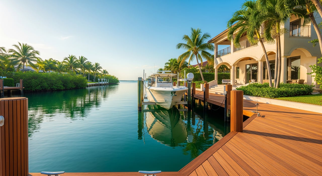
- ICW access via inlet: Your canal connects to the Intracoastal Waterway, then to the ocean through a public inlet such as Hillsboro Inlet or Port Everglades. Bridge clearances and channel depths along the route can limit vessel size.
- Limited or tidal access: Some canals are shallow at low tide or narrow near their mouths. Draft, tides and shoaling can restrict when and how you move a boat.
To reduce confusion, look for specifics in listings such as “no fixed bridges,” “X minutes to nearest inlet,” “private dock with bulkhead,” and “depth at mean low tide.” If you do not see these details, ask for them.
Routes to the Atlantic
Lighthouse Point sits on a canal system that feeds into the Intracoastal Waterway. From there, boaters typically use one of two public inlets:
- Hillsboro Inlet to the north
- Port Everglades Inlet to the south
How long it takes to reach open ocean depends on where your dock is, your vessel speed, and ICW traffic. As a rule of thumb, expect about 10 to 30 or more minutes by powerboat from most Lighthouse Point canals. Sailboats and deeper draft vessels may need more time, especially at lower tides or in heavy traffic.
Bridges and depth: what limits your boat
Two factors usually define true access: vertical clearance and water depth.
- Vertical clearance: If your route includes bridges, confirm whether they are fixed or drawbridges and the clearance at mean high water. The phrase no fixed bridges signals that tall-masted vessels can pass.
- Depth and draft: Canal and ICW depths vary with tides, storms and dredging cycles. Some canals are shallow at low tide, which can limit deeper-keel sailboats and larger yachts.
Shoaling near inlet approaches and canal mouths is common and can change over time. Check current navigation information and verify the exact route your boat would take to the inlet. A quick conversation with local marine officials or a marine surveyor can save you headaches later.
Permits, seawalls, and your responsibilities
Waterfront ownership comes with added responsibilities. If you plan to build or modify docks, boat lifts or seawalls, you will need local building and zoning approvals. Work that affects mangroves or coastal resources can also require state-level review.
Homeowners are typically responsible for maintaining seawalls and bulkheads. Replacement or elevation usually requires permits and engineered plans. If your canal is governed by a private association, confirm who must fund any dredging or shared seawall work.
Riparian rights in Florida give waterfront owners reasonable access to the water, subject to public navigation and any recorded easements. Verify whether your dock sits fully on your lot and whether any neighbors have shared rights.
Insurance, value, and financing
Waterfront homes with usable docks and reliable access usually command a price premium compared to similar non-waterfront properties. The size and condition of the dock, the seawall’s integrity, and actual navigability all influence value.
Plan for higher ongoing costs. Seawall maintenance, dock repairs, lift servicing, and potential contributions to dredging can add up. Insurance is also a key factor. Properties in flood zones often require flood insurance, and windstorm or hurricane coverage may be separate or carry higher premiums.
Lenders and appraisers will look closely at flood risk, elevation, seawall condition and dock usability. Expect underwriting questions about elevation certificates, past storm repairs and documented permits.
Buyer checklist: verify ocean access
Do not rely on a single line in a listing. Use this checklist to confirm the details that matter for Lighthouse Point:
Documents and records
- Survey showing boundaries, mean water lines, dock and bulkhead locations.
- Permits for any seawall, dock or lift work, plus any recorded easements.
- Seawall engineering reports or repair invoices if available.
- Flood zone designation and the latest elevation certificate.
- Canal dredging history and any scheduled maintenance plans.
Physical and technical inspections
- Marine survey or diver soundings to confirm depth at mean low tide.
- Structural inspection of dock, pilings and lift equipment.
- Visual check for erosion, scouring and any mangrove impacts.
Navigation and operations
- Identify every bridge on your route and verify clearance against your vessel’s air draft.
- Time the trip from your dock to Hillsboro or Port Everglades Inlet under normal conditions.
- Review current navigation notices for shoaling or obstructions.
Regulatory and financial
- Confirm permit compliance for past work on the dock or seawall.
- Get written quotes for flood and wind insurance based on the exact structure.
- Ask your lender about elevation requirements and any special conditions.
Seller tips: market ocean access with proof
If you are selling, replace vague claims with specifics. Buyers pay for confidence. Present a clear, documented picture of your property’s access and condition.
- List the route to the nearest inlet and typical travel time in normal conditions.
- State bridge types and the vertical clearance at mean high water.
- Provide dock dimensions, lift capacity and depth at mean low tide.
- Share recent permits, seawall reports and any dredging updates.
- Note any HOA or municipal rules related to docking or mooring.
A concise packet with these items reduces objections, speeds negotiations and supports your price.
Common mistakes to avoid
- Assuming all “ocean access” listings are equal. Clarify bridges, depths and inlet distance.
- Skipping a marine survey. Depth and underwater conditions are not always visible.
- Ignoring flood and wind insurance quotes until the last minute. Premiums can affect budget.
- Overlooking permit history. Unpermitted work can delay closings and increase costs.
- Waiting to price until after feedback. Factor seawall condition, lift capacity and true access from day one.
Ready to compare properties or prep your sale?
Waterfront in Lighthouse Point is a lifestyle and an investment. When you match the right dock, depth and bridge profile to your boat and budget, you win on both. Clear due diligence will help you move forward with confidence.
If you want a property-specific plan, reach out to Linda’s boutique, high-touch team for a tailored review of access, permits, insurance and go-to-market strategy. Connect with Linda Hoyt to get started.
FAQs
In Lighthouse Point, does “ocean access” let my sailboat reach the Atlantic?
- Not always, because fixed bridges and shallow canals can limit tall masts and deeper keels; verify bridge clearances at mean high water and depths at mean low tide along the full route to a public inlet.
How long does it take from a Lighthouse Point canal to the ocean?
- Typical powerboat transit to Hillsboro or Port Everglades Inlet ranges from about 10 to 30 or more minutes depending on your exact location, speed and ICW traffic.
Who pays for dredging near my dock in Lighthouse Point?
- It depends on whether the waterway is public or private and on recorded covenants; federal or county entities may maintain certain channels, while private canals often require owners or associations to fund dredging.
What permits are needed to build or repair a dock or seawall in Lighthouse Point?
- Expect local building and zoning permits plus county and state approvals for work that affects marine resources, with engineered plans commonly required for seawalls and lifts.
Will owning a waterfront home raise my insurance costs in Lighthouse Point?
- Usually yes, since flood and windstorm coverage are often higher for waterfront properties, and underwriting may be stricter based on elevation, location and past losses.